AQUILINE-AERO.COM
Эксплуатация, продажа и аренда воздушных судов. Самолеты Ан-24, Ан-26, Ан-26Б-100. Приобретение и продажа запасных частей к самолетом Российского производства.
ТРАСТ АэроСуперМаркет - электронная доска бесплатных объявлений авиационной тематики, место, где каждый желающий может вывесить свое объявление, а все посетители этой доски - прочитать его.
Контакты
Головной Офис Объединенные Арабские Эмираты Международный Аэропорт Шарджа
тел.: +971 6 5570710
факс: +971 6 5570495
По вопросам продаж: sales@trast-aero.com
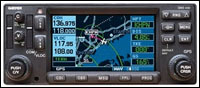
Combines 16 watt VHF communications transceiver, VHF navigation and UHF glideslope receivers, 12-channel GPS receiver with color moving map
WAAS and LAAS compatible GPS receiver
760 channel VHF comm with 25khz spacing; software configurable for 2280 channels (8.33 kHz spacing) for Europe
Provides both course deviation and optional roll steering outputs to aircraft flight guidance systems which will enable ARINC 424 lateral guidance procedures including IFR arrivals, departures and approaches
Automatically will nominate appropriate VOR and localizer frequencies for VHF navaid
Sends correct ATIS, approach, clearance, tower or ground control frequency to the comm radio at the touch of a button
16-color, active-matrix LCD measuring approximately 2" high and 3" wide with a resolution of 128 by 240 pixels
Cartographic database displays geopolitical boundaries, federal interstate highways, state routes, major local thoroughfares, plus railroads, rivers, coastlines and lakes
Can be interfaced to main indicators such as KI-202/203/204/206/208/208A/209/209A
Can be interface to Bendix/King RMI units such as KI-229 and KNI-582
Can tune most panel mount DME and remote mount DME units
Interaces to ARINC 429 EFIS systems such as Sandel SN3308 and Bendix/King EFIS 40 & 50
RS-232 and RS-422 serial ports for interfacing
ARINC 429 digital output (GAMA standard) for left/right analog course deviation, ng, encoded or greycode altitude, and basic fuel flow sensor links
Fuel Flow page configurable to allow for simultaneous display of left and right engine fuel flows
ARINC 429 digital output compatible with some autopilots which can accept ARINC 429 roll-steering information
ARINC 429 output data can be used with digital to analog adapter such as Allied Signal KA-90 to produce roll-steering signal used by autopilots systems requiring analog signal
Accepts RS-232 fuel flow data from external sources
28 Volt or 14 Volt operation
TSO'd
Interfaces to BF Goodrich WX-500 Weather Mapping Sensor and Skywatch Traffic Advisory System for combined moving map display with nav data and weather/traffic information
Interfaces to Ryan 9900B / 9900BX TCAD and Goodrich Skywatch to display traffic information
XM WX satellite weather service via GDL 69 available in 2005Non-TAWS terrain advisory feature available 2004/2005
WAAS upgrade available via software/hardware upgrade 2004/2005
Approaches: Non-precision and precision approaches throughtout the database coverage
Waypoints: 1000 user-defined
Emergency Search: 9 nearest airports, VOR's, NDB's, intersections, or user waypoints; 2 nearest FSS with frequncies; 2 nearest ARTCC frequencies
Receiver: PhaseTrac12, 12 parallel channel receiver, simultaneously tracks and uses up to 12 satellites
Update Rate: 1/second, continuous
Nav Features: Pilot-defined Course Selection and Waypoint Hold, Closest Point of Approach, Departure and Arrival Frequencies, Approach Navigation using published approach procedures stored on NavData card, Terminal Navigation using SIDs/STARs from NavData card
Frequencies: Approach, arrival, control area, departure, Class B, Class C, TMA, TRSA-with sector, altitude and text usage info, also, ASOS, ATIS, AWOS, center, clearance delivery, ground, pre-taxi, tower, unicom, localizer and ILS
FSS: Identifier, reference VOR, freq. usage
MSA: Minimum safe altitude along and in proximity to active flight plan
SIDs/STARs: Contains all pilot-nav SIDs and STARs
Flight Plans: 20 reversible; up to 31 waypoints each
Alarms: Arrival and CDI, timers, SUAs less than 10 min, 2NM and insude SUA
Planning Features: True Airspeed, Density Altitude, Winds Aloft, RAIM Availability, Sunrise/Sunset Times, Trip and Fuel Planning, Vertical Navigation (VNAV)
Map Datums: 124 predefined, 1 user defined
VOR/LOC Composite: 0.50Vrms/0.35Vrms
Centering Accuracy: +-2.0 deg.
DME Channeling: 2x5 available
VOR Audio Output: -103.5 mW minimum into 500 ohm load; external amplifier required
GS CDI Output: +-150mV Full Scale
LOC CDI Output: +-150mV Full Scale
LOC Flag Sens.: -103.5 dBm
Weight: 6.6 lbs.
Power: 27.5 VDC (14V version available Summer 1999)
VHF Frequency Range: 118.000 MHz to 136.976 MHz
Comm Modulation: 70%
Comm Channels: 760 (25 Khz spacing); configuration for 2280 channels (8.33 kHz spacing) also provided
Squelch Sensitivity: 2.0 microvolts typical
Temperature: -20 to +55C operating
Altitude Range: -1500 ft. to 50000 ft.
Модификации
Чертежный номер
Описание
010-00286-01
GPS System (Black Faceplate). IFR GPS/16 watt Comm/VOR/LOC & glideslope with color display. Available with Americas or International datacard (Worldwide available at additional charge)
010-00286-11
GPS System (Gray Faceplate). IFR GPS/16 watt Comm/VOR/LOC & glideslope with color display. Available with Americas or International datacard (Worldwide available at additional charge)