AQUILINE-AERO.COM
Эксплуатация, продажа и аренда воздушных судов. Самолеты Ан-24, Ан-26, Ан-26Б-100. Приобретение и продажа запасных частей к самолетом Российского производства.
ТРАСТ АэроСуперМаркет - электронная доска бесплатных объявлений авиационной тематики, место, где каждый желающий может вывесить свое объявление, а все посетители этой доски - прочитать его.
Контакты
Головной Офис Объединенные Арабские Эмираты Международный Аэропорт Шарджа
тел.: +971 6 5570710
факс: +971 6 5570495
По вопросам продаж: sales@trast-aero.com
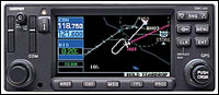
Jeppesen database (front-loading data card) contains all airports, VORs, NDBs, intersections, FSS, Approach, SIDs/STARs, and SUA information
Offers enhanced situational awareness with relation to cities, highways, railroads, rivers, lakes and coastlines
Use of color separates land data, terminal areas, route, and approach information for easy pilot scanning
TSO C129a certified for non-precision approach
Frequency nomination feature loads Comm frequency into standby ith touch of button
Self-contained unit with annunciation included in one box eliminating need for separate annunciation unit
Real time weather data available to be displayed via GDL 49 subsriber communicator interface. VHF comm transceiver will receives information from the Echoflight satelitte information system. Interface has three ports for dual GNS430/530 usuage plus a third port for interface to laptop computer to send and receive e-mail.
Non-certified terrain advisory feature available
WAAS upgrade available via software/hardware upgrade
Intersections: Identifier, country, lat/lon, nearest VOR
Frequencies: Approach, arrival, control area, departure, Class B, Class C, TMA, TRSA (with sector, altitude, and text usage info), ASOS, ATIS, AWOS, center clearance delivery, tower, ground, unicom, pre-taxi, localizer, and ILS
Runways: Designation, length, width, surface, lighting, pilot-controlled lighting frequency
FSS: Identifier, reference VOR, frequency, usage
ARTCC: Identifier, frequency, usage
MSA: Minimum safe altitude along and in proximity to active flight plan
Approaches: Non-precision and precision approaches throughout the database coverage
SIDs/STARs: Contains all pilot/nav SIDs/STARs
Airspaces: Class B & C with sectors; International CTA & TMA with sectors; all SUAs, including MOAs; prohibited and restricted areas with controlling agency and airport
Safety Features
Emergency Search: 9 nearest airports, VORs, NDBs, intersections, or user waypoints; 2 nearest FSS and ARTCC frequencies
Alarms: Arrival; timers; airspace alarms at 10 minutes, 2nm, and inside SUA
User Customization
Waypoints: 1,000 User Defined
Flight Plans: 20 reversible routes of up to 31 waypoints each
VHF COM Performance
Frequency Display: Upper-left corner of active matrix LCD, 2-lines with active frequency above standby
Channels: 760 (25 kHz spacing); configuration for 3040 channels (8.33 kHz spacing) also provided
Frequency Range: 118.000 MHz to 136.975 MHz
Transmit Power: 16 watts (minimum)
Modulation: 70% (minimum)
Receive Sensitivity: 2.0 microvolts (hard) for 6 dB S/N with 1 kHz 30% mod.
Nav Features: Pilot-defined Course Selection and Waypoint Hold, Closest Point of Approach, Departure and Arrival Frequencies, Approach Navigation using published approach procedures stored on NavData card, Terminal Navigation using SIDs/STARs from NavData card
Planning Features: True Airspeed, Density Altitude, Winds Aloft, RAIM Availability, Sunrise/Sunset Times, Trip and Fuel Planning, Vertical Navigation (VNAV)
Interfaces: ARINC 429, Aviation RS-232, CDI/HSI, RMI (digital clock/data); Superflag Out, Altitude (Gillham/Greycode and serial), Fuel Sensor, Fuel/Air Data
Map Datums: 124 and 1 user-defined
Physical Specifications
Unit Size: Width = 6.25"; Height = 2.65"; Depth = 11.00" behind panel, with connectors
Unit Weight: 6.6 pounds installed
Display: Color LCD
Power: 11-33 VDC
Data Storage: Separate internal battery protects stored data for up to five years
Environmental
Temperature: -20°C to +55°C (operating range); -20°C to +70°C (short-term operation)
Humidity: 95% non-condensing
Altitude Range: -1,500 ft to 50,000 ft
Модификации
Чертежный номер
Описание
010-00287-01
GPS System (Black Faceplate). WAAS upgradeable IFR GPS/16 watt Comm with color display. Available with Americas or International datacard (Worldwide available at additional charge)
010-00287-11
GPS System (Gray Faceplate). WAAS upgradeable IFR GPS/16 watt Comm with color display. Available with Americas or International datacard (Worldwide available at additional charge)